
Investor Duo Spends $171.4M on SE Retail Portfolio
Investor Duo Spends $171.4M on SE Retail Portfolio
CBRE arranged a $171.4 million loan to refinance the “Southeast Grocery-Anchored Portfolio” (Portfolio), which includes eight properties located throughout Tennessee, Kentucky, Georgia and Florida. The portfolio totals nearly 1.2 million square feet of retail space and was 96.6% leased at the time of the transaction.
The CBRE team, consisting of Richard Henry, Mike Ryan, Brian Linnihan, and Taylor Crowder, represented Branch Properties and Corebridge Real Estate Investors, the owners of the Portfolio. PGIM provided the loan.
The Southeast Grocery-Anchored Portfolio is a highly diversified portfolio totaling eight properties and 194 tenants, with grocery anchors including Publix, Kroger and Whole Foods, across high-growth southeastern markets, including Bradenton, FL; Sarasota, FL; Melbourne, FL; Palm Coast, FL; Atlanta, GA; Gainesville, GA; Lexington, KY; Memphis, TN; and Knoxville, TN.
The post Investor Duo Spends $171.4M on SE Retail Portfolio appeared first on Connect CRE.
CBRE arranged a $171.4 million loan to refinance the “Southeast Grocery-Anchored Portfolio” (Portfolio), which includes eight properties located throughout Tennessee, Kentucky, Georgia and Florida. The portfolio totals nearly 1.2 million square feet of retail space and was 96.6% leased at the time of the transaction. The CBRE team, consisting of Richard Henry, Mike Ryan, Brian Linnihan, and Taylor Crowder, …
The post Investor Duo Spends $171.4M on SE Retail Portfolio appeared first on Connect CRE. Read MoreAtlanta & Southeast Commercial Real Estate News
CBRE arranged a $171.4 million loan to refinance the “Southeast Grocery-Anchored Portfolio” (Portfolio), which includes eight properties located throughout Tennessee, Kentucky, Georgia and Florida. The portfolio totals nearly 1.2 million square feet of retail space and was 96.6% leased at the time of the transaction. The CBRE team, consisting of Richard Henry, Mike Ryan, Brian Linnihan, and Taylor Crowder, …
The post Investor Duo Spends $171.4M on SE Retail Portfolio appeared first on Connect CRE.
Beltline study whittles down potential transit stop locations, more
Beltline study whittles down potential transit stop locations, more
Beltline study whittles down potential transit stop locations, more
Josh Green
Mon, 11/11/2024 – 08:17
An analysis that could be the first step toward transforming mobility options across huge sections of Atlanta is making progress. Project leaders are now seeking public input to help determine where it goes next.
Atlanta Beltline Inc. kicked off the Beltline Transit Study in September 2023 to analyze the potential future of mobility around all sections of the 22-mile loop, excluding the northeast quadrant from Old Fourth Ward up to the Lindbergh area, where MARTA is conducting its own transit study.
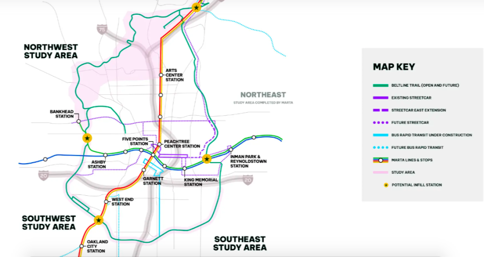
Alongside a consultant team lead by Kimley-Horn, the Beltline has wrapped the study’s first phase. It pinpoints where transit routes could go—and where up to 21 stops could be located—but it doesn’t specify which mode of transportation would be used.
That’s where the general public’s input comes in.
The Beltline Transit Study survey will be available online until Dec. 1 as a means of gathering 2 cents from Atlantans with an interest in the Beltline’s transit future. (Our test-run took seven minutes total.) It’s a chance for Beltline users to share thoughts on transit alignments, station locations, and routes, and to input data on Beltline usage today, and future transportation and travel modes.
“By participating in the survey,” officials note, “you’ll play a key role in helping the Beltline shape the future of Atlanta’s transit.”
![]()
Overview of the roughly 13-mile corridor being studied. Atlanta BeltLine Inc.
The study focuses on corridors broken down into northwest, southwest, and southeast, and it aims to reflect the needs and future transit use that’s unique to each part of town.
Clockwise, the 13 total miles analyzed span from Glenwood Park, just south of Interstate 20 on the eastside, around to Bankhead and up into Buckhead near MARTA’s Lindbergh Center station.
For the southeast section, stretching from Glenwood Park around to West End, 14 stations initially proposed have been whittled down to seven.
![]()
Where current, tentative plans call for seven stations to be placed in the southeast corridor. Atlanta BeltLine Inc.
In the southwest quadrant, analysts have recommended that six stations move forward, dotted from near the Lee + White mixed-use district up to Donald Lee Hollowell Parkway.
![]()
The six draft station locations planners have recommended to move forward in the study’s southwest quadrant.Atlanta BeltLine Inc.
Lastly, the northwest quadrant is trickiest. That’s where a transit route will have to weave through residential districts without use of a former rail corridor, like the Beltline trail itself in the area.
Analysts have narrowed down 18 potential routes for that corridor to five alternatives. Four of those would link to Atlantic Station, while one would remain farther north.
![]()
The northwest corridor’s five potential transit alignments. Atlanta BeltLine Inc.
“Each alignment,” Beltline planners note, “has the potential to connect to the proposed MARTA infill station at Armour Yards or, if necessary, reach the Lindbergh Center MARTA station.”
According to the latest study timeline, funding options for transit routes will be explored next year, and all work including financial planning and ridership forecasting is expected to wrap by late 2025.
Beltline officials will use engineers’ and public input to reveal a Locally Preferred Alternative at that time.
![]()
Light-rail operations and potential look of a stop shown near Pittsburgh Yards on the Southside Trail. Atlanta BeltLine Inc.
![]()
Atlanta BeltLine Inc.
…
Follow us on social media:
Twitter / Facebook/and now: Instagram
• Mayor unveils plan to spur affordable housing in high-growth areas (Urbanize Atlanta)
![]()
Overview of the roughly 13-mile corridor being studied. Atlanta BeltLine Inc.
![]()
Light-rail operations and potential look of a stop shown near Pittsburgh Yards on the Southside Trail. Atlanta BeltLine Inc.
![]()
The six draft station locations planners have recommended to move forward in the study’s southwest quadrant.Atlanta BeltLine Inc.
![]()
Where current, tentative plans call for seven stations to be placed in the southeast corridor. Atlanta BeltLine Inc.
![]()
The northwest corridor’s five potential transit alignments. Atlanta BeltLine Inc.
![]()
Atlanta BeltLine Inc.

Beltline study whittles down potential transit stop locations, more
Josh Green
Mon, 11/11/2024 – 08:17
An analysis that could be the first step toward transforming mobility options across huge sections of Atlanta is making progress. Project leaders are now seeking public input to help determine where it goes next.
Atlanta Beltline Inc. kicked off the Beltline Transit Study in September 2023 to analyze the potential future of mobility around all sections of the 22-mile loop, excluding the northeast quadrant from Old Fourth Ward up to the Lindbergh area, where MARTA is conducting its own transit study.
Alongside a consultant team lead by Kimley-Horn, the Beltline has wrapped the study’s first phase. It pinpoints where transit routes could go—and where up to 21 stops could be located—but it doesn’t specify which mode of transportation would be used.
That’s where the general public’s input comes in.
The Beltline Transit Study survey will be available online until Dec. 1 as a means of gathering 2 cents from Atlantans with an interest in the Beltline’s transit future. (Our test-run took seven minutes total.) It’s a chance for Beltline users to share thoughts on transit alignments, station locations, and routes, and to input data on Beltline usage today, and future transportation and travel modes.
“By participating in the survey,” officials note, “you’ll play a key role in helping the Beltline shape the future of Atlanta’s transit.”
Overview of the roughly 13-mile corridor being studied. Atlanta BeltLine Inc.
The study focuses on corridors broken down into northwest, southwest, and southeast, and it aims to reflect the needs and future transit use that’s unique to each part of town.
Clockwise, the 13 total miles analyzed span from Glenwood Park, just south of Interstate 20 on the eastside, around to Bankhead and up into Buckhead near MARTA’s Lindbergh Center station.
For the southeast section, stretching from Glenwood Park around to West End, 14 stations initially proposed have been whittled down to seven.
Where current, tentative plans call for seven stations to be placed in the southeast corridor. Atlanta BeltLine Inc.
In the southwest quadrant, analysts have recommended that six stations move forward, dotted from near the Lee + White mixed-use district up to Donald Lee Hollowell Parkway.
The six draft station locations planners have recommended to move forward in the study’s southwest quadrant.Atlanta BeltLine Inc.
Lastly, the northwest quadrant is trickiest. That’s where a transit route will have to weave through residential districts without use of a former rail corridor, like the Beltline trail itself in the area.
Analysts have narrowed down 18 potential routes for that corridor to five alternatives. Four of those would link to Atlantic Station, while one would remain farther north.
The northwest corridor’s five potential transit alignments. Atlanta BeltLine Inc.
“Each alignment,” Beltline planners note, “has the potential to connect to the proposed MARTA infill station at Armour Yards or, if necessary, reach the Lindbergh Center MARTA station.”
According to the latest study timeline, funding options for transit routes will be explored next year, and all work including financial planning and ridership forecasting is expected to wrap by late 2025.
Beltline officials will use engineers’ and public input to reveal a Locally Preferred Alternative at that time.
Light-rail operations and potential look of a stop shown near Pittsburgh Yards on the Southside Trail. Atlanta BeltLine Inc.
Atlanta BeltLine Inc.
…
Follow us on social media:
Twitter / Facebook/and now: Instagram
• Mayor unveils plan to spur affordable housing in high-growth areas (Urbanize Atlanta)
Tags
Beltline Transit
Beltline Transit Study
Alternate Transportation
Beltline
Atlanta BeltLine
Kimley-Horn
Kimley Horn
Kimley-Horn & Associates
Atlanta Transit
Atlanta Transportation
Images
Overview of the roughly 13-mile corridor being studied. Atlanta BeltLine Inc.
Light-rail operations and potential look of a stop shown near Pittsburgh Yards on the Southside Trail. Atlanta BeltLine Inc.
The six draft station locations planners have recommended to move forward in the study’s southwest quadrant.Atlanta BeltLine Inc.
Where current, tentative plans call for seven stations to be placed in the southeast corridor. Atlanta BeltLine Inc.
The northwest corridor’s five potential transit alignments. Atlanta BeltLine Inc.
Atlanta BeltLine Inc.
Subtitle
Planners seek 2 cents from general public on 13-mile transportation system plans
Neighborhood
Citywide
Background Image
Image
Before/After Images
Sponsored Post
Off Read More
Beltline study whittles down potential transit stop locations, more
Josh Green
Mon, 11/11/2024 – 08:17
An analysis that could be the first step toward transforming mobility options across huge sections of Atlanta is making progress. Project leaders are now seeking public input to help determine where it goes next.
Atlanta Beltline Inc. kicked off the Beltline Transit Study in September 2023 to analyze the potential future of mobility around all sections of the 22-mile loop, excluding the northeast quadrant from Old Fourth Ward up to the Lindbergh area, where MARTA is conducting its own transit study.
Alongside a consultant team lead by Kimley-Horn, the Beltline has wrapped the study’s first phase. It pinpoints where transit routes could go—and where up to 21 stops could be located—but it doesn’t specify which mode of transportation would be used.
That’s where the general public’s input comes in.
The Beltline Transit Study survey will be available online until Dec. 1 as a means of gathering 2 cents from Atlantans with an interest in the Beltline’s transit future. (Our test-run took seven minutes total.) It’s a chance for Beltline users to share thoughts on transit alignments, station locations, and routes, and to input data on Beltline usage today, and future transportation and travel modes.
“By participating in the survey,” officials note, “you’ll play a key role in helping the Beltline shape the future of Atlanta’s transit.”
Overview of the roughly 13-mile corridor being studied. Atlanta BeltLine Inc.
The study focuses on corridors broken down into northwest, southwest, and southeast, and it aims to reflect the needs and future transit use that’s unique to each part of town.
Clockwise, the 13 total miles analyzed span from Glenwood Park, just south of Interstate 20 on the eastside, around to Bankhead and up into Buckhead near MARTA’s Lindbergh Center station.
For the southeast section, stretching from Glenwood Park around to West End, 14 stations initially proposed have been whittled down to seven.
Where current, tentative plans call for seven stations to be placed in the southeast corridor. Atlanta BeltLine Inc.
In the southwest quadrant, analysts have recommended that six stations move forward, dotted from near the Lee + White mixed-use district up to Donald Lee Hollowell Parkway.
The six draft station locations planners have recommended to move forward in the study’s southwest quadrant.Atlanta BeltLine Inc.
Lastly, the northwest quadrant is trickiest. That’s where a transit route will have to weave through residential districts without use of a former rail corridor, like the Beltline trail itself in the area.
Analysts have narrowed down 18 potential routes for that corridor to five alternatives. Four of those would link to Atlantic Station, while one would remain farther north.
The northwest corridor’s five potential transit alignments. Atlanta BeltLine Inc.
“Each alignment,” Beltline planners note, “has the potential to connect to the proposed MARTA infill station at Armour Yards or, if necessary, reach the Lindbergh Center MARTA station.”
According to the latest study timeline, funding options for transit routes will be explored next year, and all work including financial planning and ridership forecasting is expected to wrap by late 2025.
Beltline officials will use engineers’ and public input to reveal a Locally Preferred Alternative at that time.
Light-rail operations and potential look of a stop shown near Pittsburgh Yards on the Southside Trail. Atlanta BeltLine Inc.
Atlanta BeltLine Inc.
…
Follow us on social media:
Twitter / Facebook/and now: Instagram
• Mayor unveils plan to spur affordable housing in high-growth areas (Urbanize Atlanta)
Tags
Beltline Transit
Beltline Transit Study
Alternate Transportation
Beltline
Atlanta BeltLine
Kimley-Horn
Kimley Horn
Kimley-Horn & Associates
Atlanta Transit
Atlanta Transportation
Images
Overview of the roughly 13-mile corridor being studied. Atlanta BeltLine Inc.
Light-rail operations and potential look of a stop shown near Pittsburgh Yards on the Southside Trail. Atlanta BeltLine Inc.
The six draft station locations planners have recommended to move forward in the study’s southwest quadrant.Atlanta BeltLine Inc.
Where current, tentative plans call for seven stations to be placed in the southeast corridor. Atlanta BeltLine Inc.
The northwest corridor’s five potential transit alignments. Atlanta BeltLine Inc.
Atlanta BeltLine Inc.
Subtitle
Planners seek 2 cents from general public on 13-mile transportation system plans
Neighborhood
Citywide
Background Image
Image
Before/After Images
Sponsored Post
Off

Charlotte Office Complex Trades for $328.5M
Charlotte Office Complex Trades for $328.5M
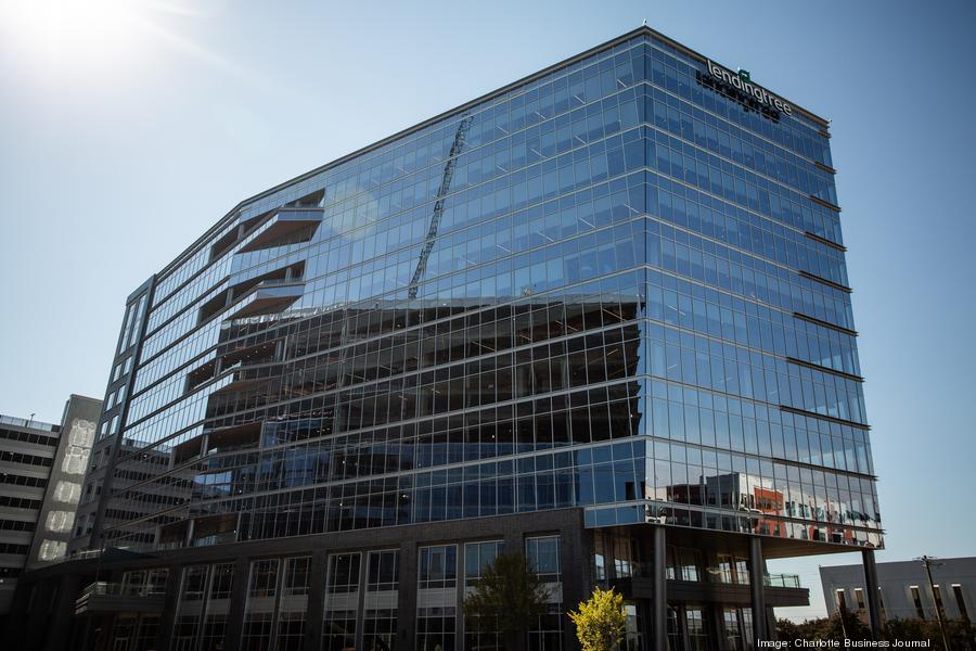
Cousins Properties purchased Vantage South End, a 639,000-square-foot office complex in Charlotte, for $328.5 million. The sellers were Invesco Real Estate and The Spectrum Cos.
The duo completed the two-building campus in 2021 and 2022. Rodgers Buildings was the general contractor, and LS3P Associates was the design firm. Initial plans for the property also included an 11-story, 200-key boutique hotel.
Vantage South End comprises two 11-story buildings that feature 45,000 square feet of retail space, a 1-acre park, 18 outdoor terraces, several fitness and conference centers, and multiple on-site dining options.
Commercial Edge reports the office complex is 97.4 percent leased with a weighted average lease term of more than nine years. Tenants include CBRE, LendingTree, Alston & Bird and Hartford Insurance.
The office complex at 1415 Vantage Park Drive and 1120 S. Tryon St. is the site of Centene’s former headquarters.
The post Charlotte Office Complex Trades for $328.5M appeared first on Connect CRE.
Cousins Properties purchased Vantage South End, a 639,000-square-foot office complex in Charlotte, for $328.5 million. The sellers were Invesco Real Estate and The Spectrum Cos. The duo completed the two-building campus in 2021 and 2022. Rodgers Buildings was the general contractor, and LS3P Associates was the design firm. Initial plans for the property also included …
The post Charlotte Office Complex Trades for $328.5M appeared first on Connect CRE. Read MoreAtlanta & Southeast Commercial Real Estate News
Cousins Properties purchased Vantage South End, a 639,000-square-foot office complex in Charlotte, for $328.5 million. The sellers were Invesco Real Estate and The Spectrum Cos. The duo completed the two-building campus in 2021 and 2022. Rodgers Buildings was the general contractor, and LS3P Associates was the design firm. Initial plans for the property also included …
The post Charlotte Office Complex Trades for $328.5M appeared first on Connect CRE.

What $10B in new Midtown ATL development looks like
What $10B in new Midtown ATL development looks like
What $10B in new Midtown ATL development looks like
Josh Green
Fri, 11/08/2024 – 16:36
In a move that’s sure to delight Atlanta development fanatics, Midtown Alliance has updated its visual summary for a subsection of the city that’s been transformed by large-scale private investment in recent years like no other.
According to the nonprofit coalition of business and community leaders, an estimated $10.3 billion has been invested over the past six years alone in the 1.2-square-mile Midtown Improvement District, or what’s generally considered the neighborhood’s commercial core.
Per Midtown Alliance’s tabulation, 53 projects have been delivered in that area since 2018, with another eight under construction now. Elsewhere, eight large-scale proposals are in the pipeline.
From a bird’s perspective, that looks like this, generally speaking:
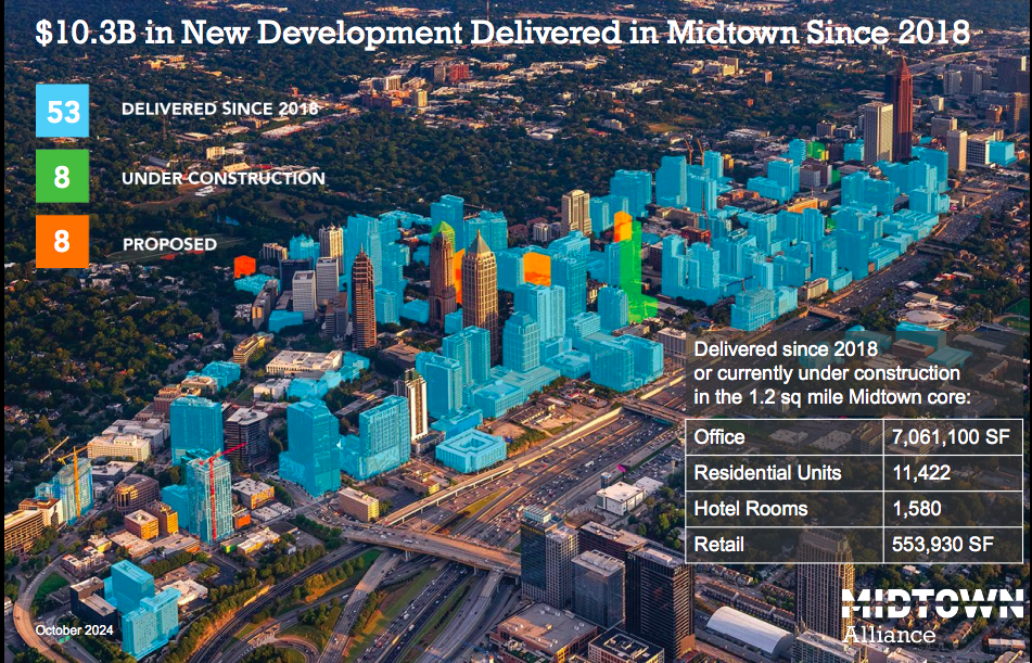
Overview of core Midtown development over the past six years, with the recent proposal neighboring The Varsity and the under-construction, two-tower Middle Street Partners project near Piedmont Park not shown. Courtesy of Midtown Alliance
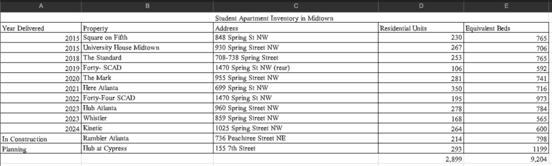
An interesting note highlighted by Midtown Alliance today is the remarkable impact student housing has made on the subdistrict in less than a decade.
Since the first major development in the student-housing category delivered in 2015—Spring Street’s University House, with its game room and poolside Jumbotron that seemed astonishingly luxurious at the time—amenity-packed, high-rise student buildings have popped up across Midtown, from former parking lots near SCAD to the edge of downtown.
Midtown Alliance estimates that between 6,000 and 7,000 of all of Midtown’s 27,000 residents are now college students.
Courtesy of Midtown Alliance
On a related note, a Landmark Properties proposal that came to light this week just north of the original, iconic The Varsity location is scheduled to be vetted Tuesday by the Midtown Development Review Committee.
An agenda for the DRC’s monthly meeting provides insight into exactly what that development might entail.
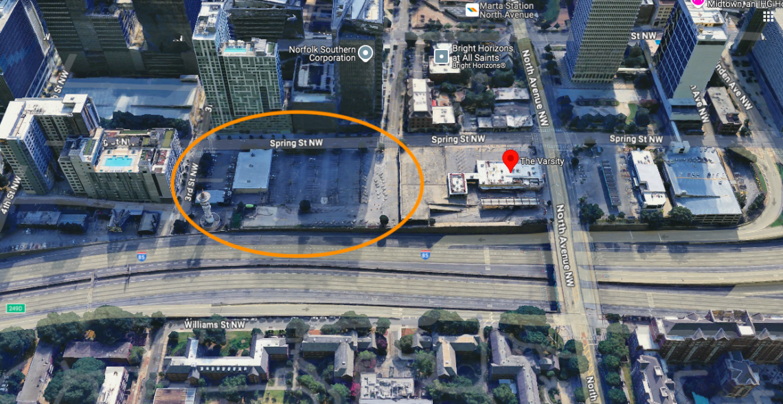
Landmark Properties’ fourth intown student-housing project would stand 34 stories over the Connector at 680 Spring St., rising in a U-shaped pattern with views down to Georgia Tech.
Plans call for 560 units, with a total of 1,992 bedrooms, per the DRC. Roughly 8,100 square feet of retail space would be situated at the corners of the building, with a leasing area in between.
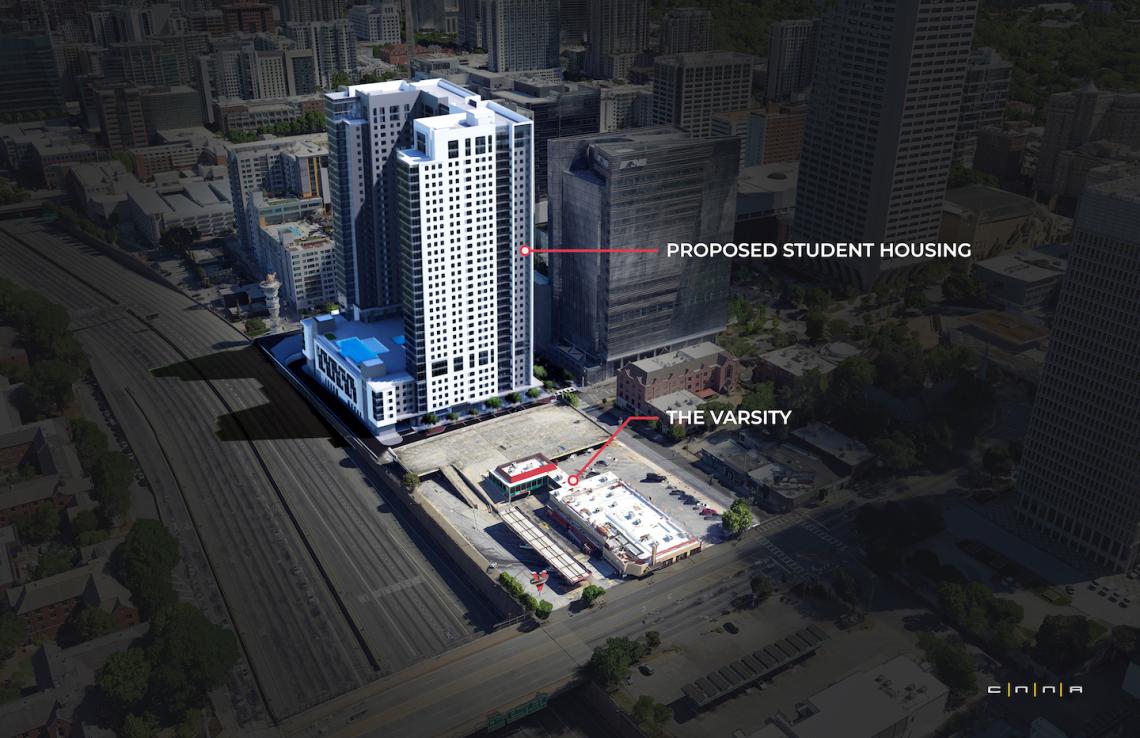
Rendering showing perspective from the south for the 1,992-bed proposal. Courtesy of Landmark Properties; designs, CNNA Architects
Current designs call for a parking podium standing six and ½ stories with 554 spaces for vehicles. Three sides of the parking structure would be wrapped with apartments, leaving the highway-facing façade exposed.
Pedestrian and bicycle access would be provided from three sides of the building, with a large bike facility situated at the southeast corner, per the DRC agenda.
Find a new perspective on how the tower could lord over the Connector over here.
…
Follow us on social media:
Twitter / Facebook/and now: Instagram
• Midtown news, discussion (Urbanize Atlanta)
Overview of core Midtown development over the past six years, with the recent proposal neighboring The Varsity and the under-construction, two-tower Middle Street Partners project near Piedmont Park not shown. Courtesy of Midtown Alliance
Courtesy of Midtown Alliance
Rendering showing perspective from the south for the 1,992-bed proposal. Courtesy of Landmark Properties; designs, CNNA Architects
Google Maps

What $10B in new Midtown ATL development looks like
Josh Green
Fri, 11/08/2024 – 16:36
In a move that’s sure to delight Atlanta development fanatics, Midtown Alliance has updated its visual summary for a subsection of the city that’s been transformed by large-scale private investment in recent years like no other.
According to the nonprofit coalition of business and community leaders, an estimated $10.3 billion has been invested over the past six years alone in the 1.2-square-mile Midtown Improvement District, or what’s generally considered the neighborhood’s commercial core.
Per Midtown Alliance’s tabulation, 53 projects have been delivered in that area since 2018, with another eight under construction now. Elsewhere, eight large-scale proposals are in the pipeline.
From a bird’s perspective, that looks like this, generally speaking:
Overview of core Midtown development over the past six years, with the recent proposal neighboring The Varsity and the under-construction, two-tower Middle Street Partners project near Piedmont Park not shown. Courtesy of Midtown Alliance
An interesting note highlighted by Midtown Alliance today is the remarkable impact student housing has made on the subdistrict in less than a decade.
Since the first major development in the student-housing category delivered in 2015—Spring Street’s University House, with its game room and poolside Jumbotron that seemed astonishingly luxurious at the time—amenity-packed, high-rise student buildings have popped up across Midtown, from former parking lots near SCAD to the edge of downtown.
Midtown Alliance estimates that between 6,000 and 7,000 of all of Midtown’s 27,000 residents are now college students.
Courtesy of Midtown Alliance
On a related note, a Landmark Properties proposal that came to light this week just north of the original, iconic The Varsity location is scheduled to be vetted Tuesday by the Midtown Development Review Committee.
An agenda for the DRC’s monthly meeting provides insight into exactly what that development might entail.
Landmark Properties’ fourth intown student-housing project would stand 34 stories over the Connector at 680 Spring St., rising in a U-shaped pattern with views down to Georgia Tech.
Plans call for 560 units, with a total of 1,992 bedrooms, per the DRC. Roughly 8,100 square feet of retail space would be situated at the corners of the building, with a leasing area in between.
Rendering showing perspective from the south for the 1,992-bed proposal. Courtesy of Landmark Properties; designs, CNNA Architects
Current designs call for a parking podium standing six and ½ stories with 554 spaces for vehicles. Three sides of the parking structure would be wrapped with apartments, leaving the highway-facing façade exposed.
Pedestrian and bicycle access would be provided from three sides of the building, with a large bike facility situated at the southeast corner, per the DRC agenda.
Find a new perspective on how the tower could lord over the Connector over here.
…
Follow us on social media:
Twitter / Facebook/and now: Instagram
• Midtown news, discussion (Urbanize Atlanta)
Tags
61 North Avenue NW
The Varsity
Midtown
Development
Big Deals
Spring Street
Atlanta Parking Lots
Atlanta Development
Atlanta Restaurants
Varsity
Georgia Tech
Midtown Alliance
AJC
Any Big Ideas
Landmark Properties
CNNA Architects
Varsity Realty Corp.
VRC
Midtown Development
Midtown Construction
Midtown Growth
Images
Overview of core Midtown development over the past six years, with the recent proposal neighboring The Varsity and the under-construction, two-tower Middle Street Partners project near Piedmont Park not shown. Courtesy of Midtown Alliance
Courtesy of Midtown Alliance
Rendering showing perspective from the south for the 1,992-bed proposal. Courtesy of Landmark Properties; designs, CNNA Architects
Google Maps
Subtitle
Plus, more details emerge for towering proposal next to The Varsity
Neighborhood
Midtown
Background Image
Image
Before/After Images
Sponsored Post
Off Read More
What $10B in new Midtown ATL development looks like
Josh Green
Fri, 11/08/2024 – 16:36
In a move that’s sure to delight Atlanta development fanatics, Midtown Alliance has updated its visual summary for a subsection of the city that’s been transformed by large-scale private investment in recent years like no other.
According to the nonprofit coalition of business and community leaders, an estimated $10.3 billion has been invested over the past six years alone in the 1.2-square-mile Midtown Improvement District, or what’s generally considered the neighborhood’s commercial core.
Per Midtown Alliance’s tabulation, 53 projects have been delivered in that area since 2018, with another eight under construction now. Elsewhere, eight large-scale proposals are in the pipeline.
From a bird’s perspective, that looks like this, generally speaking:
Overview of core Midtown development over the past six years, with the recent proposal neighboring The Varsity and the under-construction, two-tower Middle Street Partners project near Piedmont Park not shown. Courtesy of Midtown Alliance
An interesting note highlighted by Midtown Alliance today is the remarkable impact student housing has made on the subdistrict in less than a decade.
Since the first major development in the student-housing category delivered in 2015—Spring Street’s University House, with its game room and poolside Jumbotron that seemed astonishingly luxurious at the time—amenity-packed, high-rise student buildings have popped up across Midtown, from former parking lots near SCAD to the edge of downtown.
Midtown Alliance estimates that between 6,000 and 7,000 of all of Midtown’s 27,000 residents are now college students.
Courtesy of Midtown Alliance
On a related note, a Landmark Properties proposal that came to light this week just north of the original, iconic The Varsity location is scheduled to be vetted Tuesday by the Midtown Development Review Committee.
An agenda for the DRC’s monthly meeting provides insight into exactly what that development might entail.
Landmark Properties’ fourth intown student-housing project would stand 34 stories over the Connector at 680 Spring St., rising in a U-shaped pattern with views down to Georgia Tech.
Plans call for 560 units, with a total of 1,992 bedrooms, per the DRC. Roughly 8,100 square feet of retail space would be situated at the corners of the building, with a leasing area in between.
Rendering showing perspective from the south for the 1,992-bed proposal. Courtesy of Landmark Properties; designs, CNNA Architects
Current designs call for a parking podium standing six and ½ stories with 554 spaces for vehicles. Three sides of the parking structure would be wrapped with apartments, leaving the highway-facing façade exposed.
Pedestrian and bicycle access would be provided from three sides of the building, with a large bike facility situated at the southeast corner, per the DRC agenda.
Find a new perspective on how the tower could lord over the Connector over here.
…
Follow us on social media:
Twitter / Facebook/and now: Instagram
• Midtown news, discussion (Urbanize Atlanta)
Tags
61 North Avenue NW
The Varsity
Midtown
Development
Big Deals
Spring Street
Atlanta Parking Lots
Atlanta Development
Atlanta Restaurants
Varsity
Georgia Tech
Midtown Alliance
AJC
Any Big Ideas
Landmark Properties
CNNA Architects
Varsity Realty Corp.
VRC
Midtown Development
Midtown Construction
Midtown Growth
Images
Overview of core Midtown development over the past six years, with the recent proposal neighboring The Varsity and the under-construction, two-tower Middle Street Partners project near Piedmont Park not shown. Courtesy of Midtown Alliance
Courtesy of Midtown Alliance
Rendering showing perspective from the south for the 1,992-bed proposal. Courtesy of Landmark Properties; designs, CNNA Architects
Google Maps
Subtitle
Plus, more details emerge for towering proposal next to The Varsity
Neighborhood
Midtown
Background Image
Image
Before/After Images
Sponsored Post
Off
Officials detail outlook on Star Metals District’s final phase
Officials detail outlook on Star Metals District’s final phase
Officials detail outlook on Star Metals District’s final phase
Josh Green
Fri, 11/08/2024 – 14:14
Project officials behind the final phase of West Midtown’s transformative Star Metals District provided updates today regarding the scope, functionality, and ballpark timeline for the remaining section of development.
The Allen Morris Company project’s broader goal is to create something more akin to Fourth Ward Project on the flipside of Midtown than a collection of standalone towers with heavy concentrations of parking at the bases. But the tallest of those structures won’t rise as high as filings with the City of Atlanta previously suggested.
“By reducing the large parking structures that engulf the ground level, the project will be more indicative of what you commonly see in Europe and Australia, where parking is less prominent,” Max Cookes, founder of ANiMAL, a real estate investment firm and Star Metals District joint venture partner, said in the update. “This project exemplifies the district’s mission to create a cohesive, walkable, community-first area in West Midtown.”
The final phase’s 3.27-acre property spans a full city block, just west of Northside Drive and north of 10th Street, fronting Howell Mill Road. Allen Morris in 2022 succeeded in having the property rezoned to an MRC-3 designation to allow for mixed uses.
Plans call for three new towers to join the trio of Star Metals buildings (one filled with offices, the other two with apartments) that currently stand.
The tallest building in that masterplan, according to ANiMAL’s update, is now planned to rise 33 stories. A height variance developers have requested from the city would allow that tower to stand 340 feet tall, or significantly higher than the district’s height maximum of 225 feet now. The tradeoff would be that a taller and slimmer structure would allow for more large, open public spaces at the ground level.
That building’s coverage on the lot, at 33 stories, would shrink from 65 to 35 percent. According to ANiMAL reps, buildings with MRC-3 zoning typical cover 85 percent of their lots.
City officials are expected to make a decision on the height variance in December.

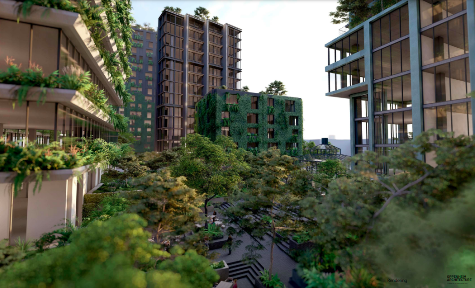
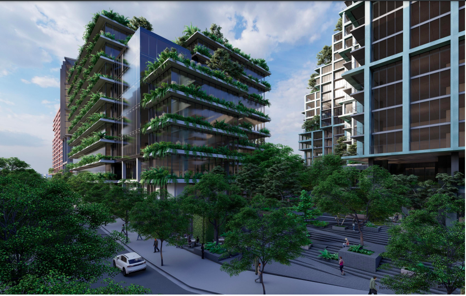
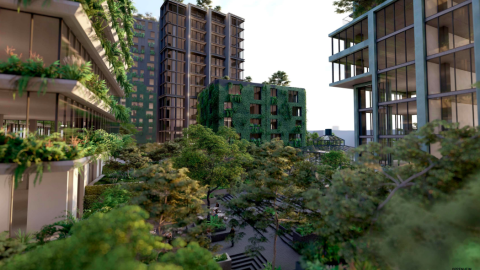
Renderings supplied by project officials this week showing the aesthetic and tentative scale of Star Metals’ final phase. Allen Morris Company; Oppenheim Architecture
If approved, the 33-story residential building would still stand out in the Marietta Street Artery neighborhood, but it would be significantly shorter than initial designs floated last summer. Those called for a 42-story structure topping out around 435 feet tall. (For context, the building’s current scope would still stand 11 stories taller than the Stella at Star Metals apartments, which have topped out at a site immediately to the east.)
In any case, the 33-story proposal might not break ground for several years. Two other phases of development with shorter towers are scheduled to be built first, with the first of those buildings, a residential component, on track to break ground in late 2025, according to the update.
Allen Morris Company; Oppenheim Architecture
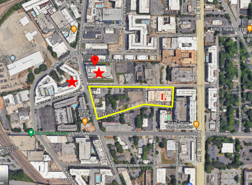
Blocks where Star Metals District is expected to expand (in yellow), between Howell Mill Road (left) and Northside Drive. Red stars represent existing Star Metals buildings, while the section marked “1” is where the 22-story Stella building is under construction. Google Maps/Urbanize ATL
But there’s good news for outdoor recreation enthusiasts in the short term.
The portion of the site where the tallest building would rise—currently a warehouse—will be transformed on an interim basis into an open-air hangout and retail space called Star Metals Park, designed to be a focal point for the growing area. Plans call for a large greenspace and landscaped areas, indoor and outdoor seating, an internal kitchen, and restrooms, according to ANiMAL reps.
Renderings that surfaced in January lent an idea what that space could look like, but project officials tell Urbanize Atlanta the concept for Star Metals Park has evolved since then. Renderings and details on an operator for that facet of the district are expected to be available within the next month, we’re told.
The first build building in Star Metals District’s final phase will take about two years to build, meaning it would open roughly in the fourth quarter of 2027, officials tell Urbanize.
The project’s emphasis on outdoor, public-accessible elements has won the support of the area’s Upper Westside Community Improvement District.
“The Marietta Street Artery neighborhood has no City of Atlanta parks, [and] projects such as this one are helping fill the greenspace deficit in our district,” Adeline Collot, the CID’s planning and capital projects program director, said in the update. “We welcome developments that create ample and thoughtfully designed spaces for the community’s use, given the growing number of residents in the area.”
…
Follow us on social media:
Twitter / Facebook/and now: Instagram
• Marietta Street Artery news, discussion (Urbanize Atlanta)
Renderings supplied by project officials this week showing the aesthetic and tentative scale of Star Metals’ final phase. Allen Morris Company; Oppenheim Architecture
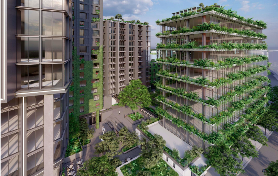
Allen Morris Company; Oppenheim Architecture
Allen Morris Company; Oppenheim Architecture
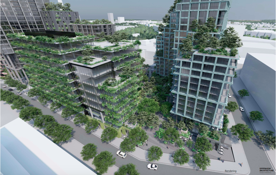
Allen Morris Company; Oppenheim Architecture
The tallest building in Star Metals’ final phases (center) as seen next to the Stella building (left) and the project’s existing office stack on Howell Mill Road (right). Dwell Design Studio; The Allen Morris Company; via City of Atlanta Office of Zoning and Development
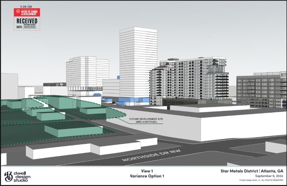
Looking west over Northside Drive, the context of Star Metals’ phased proposals (at center) with the under-construction Stella at Star Metals tower (at right) and second phase of Interlock (at far right). Dwell Design Studio; The Allen Morris Company; via City of Atlanta Office of Zoning and Development
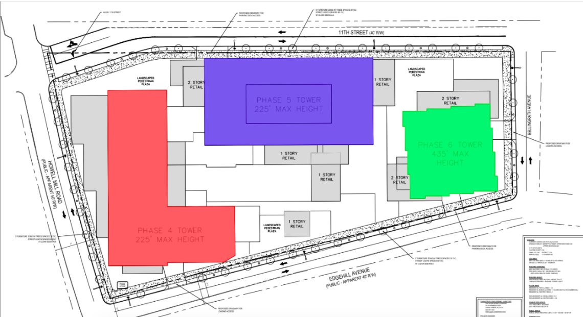
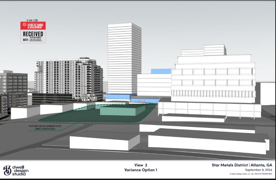
Potential layout of the three buildings, plazas, and retail boxes in Star Metals’ final phase, with the tallest, easternmost structure shown at right. Oppenheim Architecture, Allen Morris Company; via City of Atlanta Office of Zoning and Development
Blocks where Star Metals District is expected to expand (in yellow), between Howell Mill Road (left) and Northside Drive. Red stars represent existing Star Metals buildings, while the section marked “1” is where the 22-story Stella building is under construction. Google Maps/Urbanize ATL
Officials detail outlook on Star Metals District’s final phase
Josh Green
Fri, 11/08/2024 – 14:14
Project officials behind the final phase of West Midtown’s transformative Star Metals District provided updates today regarding the scope, functionality, and ballpark timeline for the remaining section of development.
The Allen Morris Company project’s broader goal is to create something more akin to Fourth Ward Project on the flipside of Midtown than a collection of standalone towers with heavy concentrations of parking at the bases. But the tallest of those structures won’t rise as high as filings with the City of Atlanta previously suggested.
“By reducing the large parking structures that engulf the ground level, the project will be more indicative of what you commonly see in Europe and Australia, where parking is less prominent,” Max Cookes, founder of ANiMAL, a real estate investment firm and Star Metals District joint venture partner, said in the update. “This project exemplifies the district’s mission to create a cohesive, walkable, community-first area in West Midtown.”
The final phase’s 3.27-acre property spans a full city block, just west of Northside Drive and north of 10th Street, fronting Howell Mill Road. Allen Morris in 2022 succeeded in having the property rezoned to an MRC-3 designation to allow for mixed uses.
Plans call for three new towers to join the trio of Star Metals buildings (one filled with offices, the other two with apartments) that currently stand.
The tallest building in that masterplan, according to ANiMAL’s update, is now planned to rise 33 stories. A height variance developers have requested from the city would allow that tower to stand 340 feet tall, or significantly higher than the district’s height maximum of 225 feet now. The tradeoff would be that a taller and slimmer structure would allow for more large, open public spaces at the ground level.
That building’s coverage on the lot, at 33 stories, would shrink from 65 to 35 percent. According to ANiMAL reps, buildings with MRC-3 zoning typical cover 85 percent of their lots.
City officials are expected to make a decision on the height variance in December.
Renderings supplied by project officials this week showing the aesthetic and tentative scale of Star Metals’ final phase. Allen Morris Company; Oppenheim Architecture
If approved, the 33-story residential building would still stand out in the Marietta Street Artery neighborhood, but it would be significantly shorter than initial designs floated last summer. Those called for a 42-story structure topping out around 435 feet tall. (For context, the building’s current scope would still stand 11 stories taller than the Stella at Star Metals apartments, which have topped out at a site immediately to the east.)
In any case, the 33-story proposal might not break ground for several years. Two other phases of development with shorter towers are scheduled to be built first, with the first of those buildings, a residential component, on track to break ground in late 2025, according to the update.
Allen Morris Company; Oppenheim Architecture
Blocks where Star Metals District is expected to expand (in yellow), between Howell Mill Road (left) and Northside Drive. Red stars represent existing Star Metals buildings, while the section marked “1” is where the 22-story Stella building is under construction. Google Maps/Urbanize ATL
But there’s good news for outdoor recreation enthusiasts in the short term.
The portion of the site where the tallest building would rise—currently a warehouse—will be transformed on an interim basis into an open-air hangout and retail space called Star Metals Park, designed to be a focal point for the growing area. Plans call for a large greenspace and landscaped areas, indoor and outdoor seating, an internal kitchen, and restrooms, according to ANiMAL reps.
Renderings that surfaced in January lent an idea what that space could look like, but project officials tell Urbanize Atlanta the concept for Star Metals Park has evolved since then. Renderings and details on an operator for that facet of the district are expected to be available within the next month, we’re told.
The first build building in Star Metals District’s final phase will take about two years to build, meaning it would open roughly in the fourth quarter of 2027, officials tell Urbanize.
The project’s emphasis on outdoor, public-accessible elements has won the support of the area’s Upper Westside Community Improvement District.
“The Marietta Street Artery neighborhood has no City of Atlanta parks, [and] projects such as this one are helping fill the greenspace deficit in our district,” Adeline Collot, the CID’s planning and capital projects program director, said in the update. “We welcome developments that create ample and thoughtfully designed spaces for the community’s use, given the growing number of residents in the area.”
…
Follow us on social media:
Twitter / Facebook/and now: Instagram
• Marietta Street Artery news, discussion (Urbanize Atlanta)
Tags
690 11th Street NW
Star Metals Hotel + Residences
Stella at Star Metals
Star Metals
Star Metals Atlanta
Oppenheim Architecture
Square Feet Studio
Atlanta Architecture
Atlanta Development
The Allen Morris Company
Star Metals District
West Midtown
Atlanta apartments
Marietta Street Artery
OMFGCo
Prevail Coffee
Savi Provisions
Flight Club
PlantHouse
Office of Zoning and Development
ANiMAL
Upper Westside Community Improvement District
Images
Renderings supplied by project officials this week showing the aesthetic and tentative scale of Star Metals’ final phase. Allen Morris Company; Oppenheim Architecture
Allen Morris Company; Oppenheim Architecture
Allen Morris Company; Oppenheim Architecture
Allen Morris Company; Oppenheim Architecture
The tallest building in Star Metals’ final phases (center) as seen next to the Stella building (left) and the project’s existing office stack on Howell Mill Road (right). Dwell Design Studio; The Allen Morris Company; via City of Atlanta Office of Zoning and Development
Looking west over Northside Drive, the context of Star Metals’ phased proposals (at center) with the under-construction Stella at Star Metals tower (at right) and second phase of Interlock (at far right). Dwell Design Studio; The Allen Morris Company; via City of Atlanta Office of Zoning and Development
Potential layout of the three buildings, plazas, and retail boxes in Star Metals’ final phase, with the tallest, easternmost structure shown at right. Oppenheim Architecture, Allen Morris Company; via City of Atlanta Office of Zoning and Development
Blocks where Star Metals District is expected to expand (in yellow), between Howell Mill Road (left) and Northside Drive. Red stars represent existing Star Metals buildings, while the section marked “1” is where the 22-story Stella building is under construction. Google Maps/Urbanize ATL
Subtitle
Goal is to echo projects in Europe and Australia “where parking is less prominent”
Neighborhood
Marietta Street Artery
Background Image
Image
Associated Project
Stella at Star Metals
Before/After Images
Sponsored Post
Off Read More
Officials detail outlook on Star Metals District’s final phase
Josh Green
Fri, 11/08/2024 – 14:14
Project officials behind the final phase of West Midtown’s transformative Star Metals District provided updates today regarding the scope, functionality, and ballpark timeline for the remaining section of development.
The Allen Morris Company project’s broader goal is to create something more akin to Fourth Ward Project on the flipside of Midtown than a collection of standalone towers with heavy concentrations of parking at the bases. But the tallest of those structures won’t rise as high as filings with the City of Atlanta previously suggested.
“By reducing the large parking structures that engulf the ground level, the project will be more indicative of what you commonly see in Europe and Australia, where parking is less prominent,” Max Cookes, founder of ANiMAL, a real estate investment firm and Star Metals District joint venture partner, said in the update. “This project exemplifies the district’s mission to create a cohesive, walkable, community-first area in West Midtown.”
The final phase’s 3.27-acre property spans a full city block, just west of Northside Drive and north of 10th Street, fronting Howell Mill Road. Allen Morris in 2022 succeeded in having the property rezoned to an MRC-3 designation to allow for mixed uses.
Plans call for three new towers to join the trio of Star Metals buildings (one filled with offices, the other two with apartments) that currently stand.
The tallest building in that masterplan, according to ANiMAL’s update, is now planned to rise 33 stories. A height variance developers have requested from the city would allow that tower to stand 340 feet tall, or significantly higher than the district’s height maximum of 225 feet now. The tradeoff would be that a taller and slimmer structure would allow for more large, open public spaces at the ground level.
That building’s coverage on the lot, at 33 stories, would shrink from 65 to 35 percent. According to ANiMAL reps, buildings with MRC-3 zoning typical cover 85 percent of their lots.
City officials are expected to make a decision on the height variance in December.
Renderings supplied by project officials this week showing the aesthetic and tentative scale of Star Metals’ final phase. Allen Morris Company; Oppenheim Architecture
If approved, the 33-story residential building would still stand out in the Marietta Street Artery neighborhood, but it would be significantly shorter than initial designs floated last summer. Those called for a 42-story structure topping out around 435 feet tall. (For context, the building’s current scope would still stand 11 stories taller than the Stella at Star Metals apartments, which have topped out at a site immediately to the east.)
In any case, the 33-story proposal might not break ground for several years. Two other phases of development with shorter towers are scheduled to be built first, with the first of those buildings, a residential component, on track to break ground in late 2025, according to the update.
Allen Morris Company; Oppenheim Architecture
Blocks where Star Metals District is expected to expand (in yellow), between Howell Mill Road (left) and Northside Drive. Red stars represent existing Star Metals buildings, while the section marked “1” is where the 22-story Stella building is under construction. Google Maps/Urbanize ATL
But there’s good news for outdoor recreation enthusiasts in the short term.
The portion of the site where the tallest building would rise—currently a warehouse—will be transformed on an interim basis into an open-air hangout and retail space called Star Metals Park, designed to be a focal point for the growing area. Plans call for a large greenspace and landscaped areas, indoor and outdoor seating, an internal kitchen, and restrooms, according to ANiMAL reps.
Renderings that surfaced in January lent an idea what that space could look like, but project officials tell Urbanize Atlanta the concept for Star Metals Park has evolved since then. Renderings and details on an operator for that facet of the district are expected to be available within the next month, we’re told.
The first build building in Star Metals District’s final phase will take about two years to build, meaning it would open roughly in the fourth quarter of 2027, officials tell Urbanize.
The project’s emphasis on outdoor, public-accessible elements has won the support of the area’s Upper Westside Community Improvement District.
“The Marietta Street Artery neighborhood has no City of Atlanta parks, [and] projects such as this one are helping fill the greenspace deficit in our district,” Adeline Collot, the CID’s planning and capital projects program director, said in the update. “We welcome developments that create ample and thoughtfully designed spaces for the community’s use, given the growing number of residents in the area.”
…
Follow us on social media:
Twitter / Facebook/and now: Instagram
• Marietta Street Artery news, discussion (Urbanize Atlanta)
Tags
690 11th Street NW
Star Metals Hotel + Residences
Stella at Star Metals
Star Metals
Star Metals Atlanta
Oppenheim Architecture
Square Feet Studio
Atlanta Architecture
Atlanta Development
The Allen Morris Company
Star Metals District
West Midtown
Atlanta apartments
Marietta Street Artery
OMFGCo
Prevail Coffee
Savi Provisions
Flight Club
PlantHouse
Office of Zoning and Development
ANiMAL
Upper Westside Community Improvement District
Images
Renderings supplied by project officials this week showing the aesthetic and tentative scale of Star Metals’ final phase. Allen Morris Company; Oppenheim Architecture
Allen Morris Company; Oppenheim Architecture
Allen Morris Company; Oppenheim Architecture
Allen Morris Company; Oppenheim Architecture
The tallest building in Star Metals’ final phases (center) as seen next to the Stella building (left) and the project’s existing office stack on Howell Mill Road (right). Dwell Design Studio; The Allen Morris Company; via City of Atlanta Office of Zoning and Development
Looking west over Northside Drive, the context of Star Metals’ phased proposals (at center) with the under-construction Stella at Star Metals tower (at right) and second phase of Interlock (at far right). Dwell Design Studio; The Allen Morris Company; via City of Atlanta Office of Zoning and Development
Potential layout of the three buildings, plazas, and retail boxes in Star Metals’ final phase, with the tallest, easternmost structure shown at right. Oppenheim Architecture, Allen Morris Company; via City of Atlanta Office of Zoning and Development
Blocks where Star Metals District is expected to expand (in yellow), between Howell Mill Road (left) and Northside Drive. Red stars represent existing Star Metals buildings, while the section marked “1” is where the 22-story Stella building is under construction. Google Maps/Urbanize ATL
Subtitle
Goal is to echo projects in Europe and Australia “where parking is less prominent”
Neighborhood
Marietta Street Artery
Background Image
Image
Associated Project
Stella at Star Metals
Before/After Images
Sponsored Post
Off
Cousins Properties to buy major Charlotte commercial development
Cousins Properties to buy major Charlotte commercial development
Cousins Properties is expected to buy a Charlotte mixed-use development for $328.5 million.
Cousins Properties is expected to buy a Charlotte mixed-use development for $328.5 million. Read MoreBizjournals.com Feed (2019-09-06 17:16:48)
Cousins Properties is expected to buy a Charlotte mixed-use development for $328.5 million.
Cousins Properties to buy major Charlotte commercial development
Cousins Properties to buy major Charlotte commercial development
Cousins Properties is expected to buy a Charlotte mixed-use development for $328.5 million.
Cousins Properties is expected to buy a Charlotte mixed-use development for $328.5 million. Read MoreBizjournals.com Feed (2022-04-02 21:43:57)
Cousins Properties is expected to buy a Charlotte mixed-use development for $328.5 million.
Six Flags Over Georgia parent company may sell some parks as part of long-term plan
Six Flags Over Georgia parent company may sell some parks as part of long-term plan
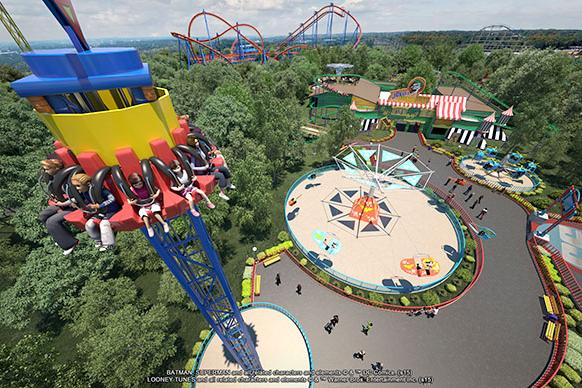
The parent company of Six Flags Over Georgia said it will conduct a “comprehensive review” of its 42 parks and may sell some of them.
The parent company of Six Flags Over Georgia said it will conduct a “comprehensive review” of its 42 parks and may sell some of them. Read MoreBizjournals.com Feed (2019-09-06 17:16:48)
The parent company of Six Flags Over Georgia said it will conduct a “comprehensive review” of its 42 parks and may sell some of them.
Six Flags Over Georgia parent company may sell some parks as part of long-term plan
Six Flags Over Georgia parent company may sell some parks as part of long-term plan
The parent company of Six Flags Over Georgia said it will conduct a “comprehensive review” of its 42 parks and may sell some of them.
The parent company of Six Flags Over Georgia said it will conduct a “comprehensive review” of its 42 parks and may sell some of them. Read MoreBizjournals.com Feed (2022-04-02 21:43:57)
The parent company of Six Flags Over Georgia said it will conduct a “comprehensive review” of its 42 parks and may sell some of them.

Chunk of East Atlanta Village-ish up for grabs
Chunk of East Atlanta Village-ish up for grabs
Chunk of East Atlanta Village-ish up for grabs
Josh Green
Fri, 11/08/2024 – 08:16
As land near cultural and economic hubs like East Atlanta Village becomes more scarce, the question becomes, in some cases, how much are developers and then homebuyers willing to put up with? Like, for instance, an interstate in the backyard?
Such is the case for a single-family home development proposal in a section of the city divided by Interstate 20 a couple of generations ago.
Marketed as being in the heart of East Atlanta Village and walkable to all that entails (prepare to trek uphill), the 513 Maynard Ave. property came to market recently with Keller Williams Realty North Atlanta, asking $1.7 million.
That buys what’s essentially 1.7 acres of woods in a residential section of East Atlanta, about .7 miles from, let’s say, Argosy. It’s billed as being a rare new-construction opportunity for the area.
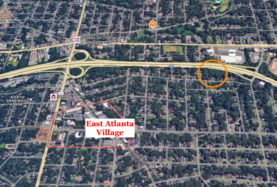
The 1.7-acre site’s proximity to EAV and I-20. Google Maps
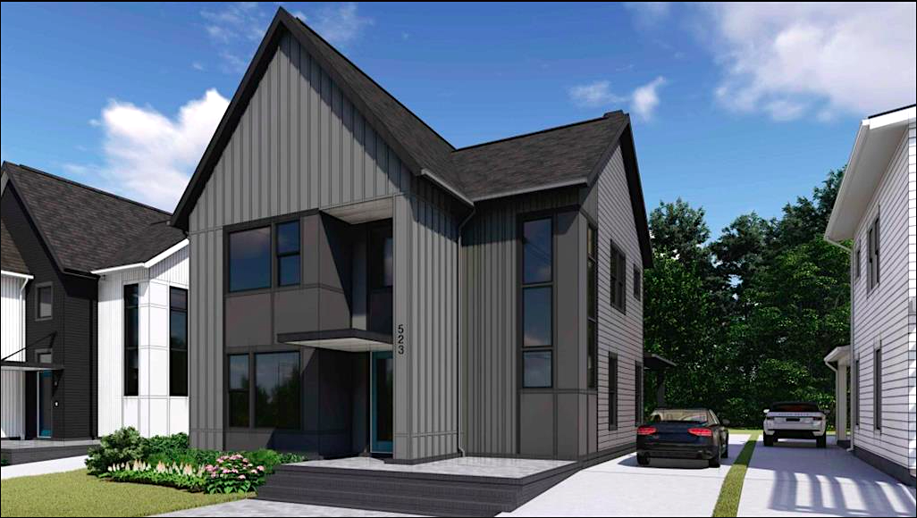
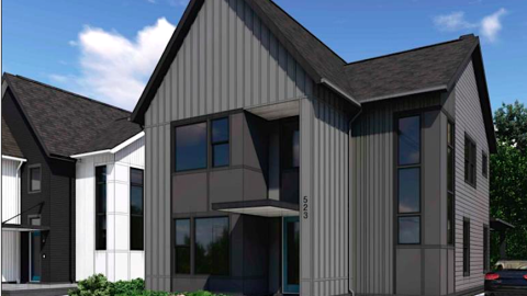
Example of housing proposed in current listings for 513 Maynard Ave. Keller Williams Realty North Atlanta/FMLS
Plans included with the purchase call for eight single-family dwellings tucked off existing streets. “Near immediate access” to I-20—westbound, at least—is called a highlight of the location. Ditto for proximity to everywhere from Summerhill to Cabbagetown.
According to listings, architectural plans, a land disturbance permit, and City of Atlanta tree recompose (essentially a fine for removing healthy trees, with funding used to plant and maintain other trees) would be included with the land sale.
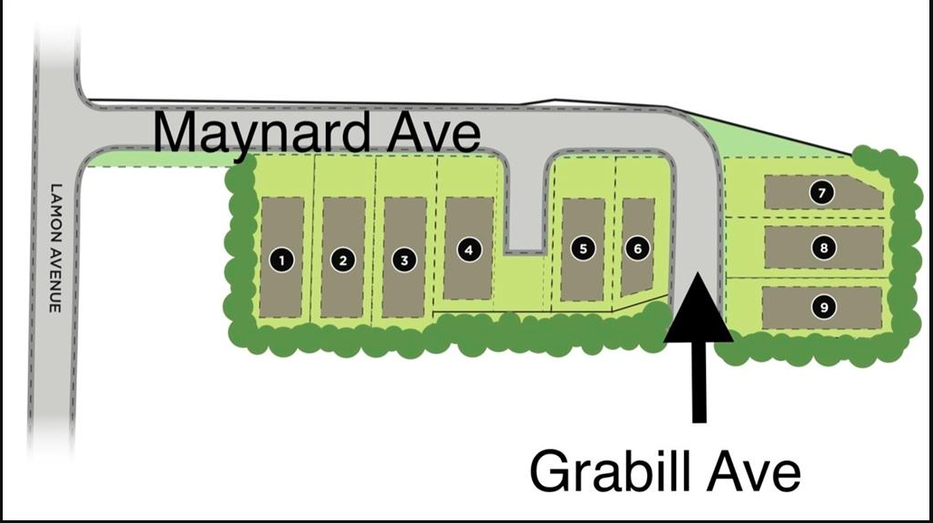
Keller Williams Realty North Atlanta/FMLS
Of the location’s algorithm-generated Walk Score ratings, the “somewhat walkable” Walk Score of 53 fares best, followed by the so-so 41 Transit Score and 36 Bike Score.
Another metric called the Sound Score—calculated by the HowLoud platform—reflects the nearby interstate, coming in at a “loud” 66.
For what that’s worth.
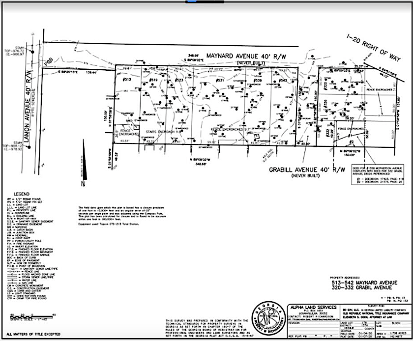
Keller Williams Realty North Atlanta/FMLS/Alpha Land Services
…
Follow us on social media:
Twitter / Facebook/and now: Instagram
• East Atlanta news, discussion (Urbanize Atlanta)
The 1.7-acre site’s proximity to EAV and I-20. Google Maps
Keller Williams Realty North Atlanta/FMLS
Example of housing proposed in current listings for 513 Maynard Ave. Keller Williams Realty North Atlanta/FMLS
Keller Williams Realty North Atlanta/FMLS/Alpha Land Services
Chunk of East Atlanta Village-ish up for grabs
Josh Green
Fri, 11/08/2024 – 08:16
As land near cultural and economic hubs like East Atlanta Village becomes more scarce, the question becomes, in some cases, how much are developers and then homebuyers willing to put up with? Like, for instance, an interstate in the backyard?
Such is the case for a single-family home development proposal in a section of the city divided by Interstate 20 a couple of generations ago.
Marketed as being in the heart of East Atlanta Village and walkable to all that entails (prepare to trek uphill), the 513 Maynard Ave. property came to market recently with Keller Williams Realty North Atlanta, asking $1.7 million.
That buys what’s essentially 1.7 acres of woods in a residential section of East Atlanta, about .7 miles from, let’s say, Argosy. It’s billed as being a rare new-construction opportunity for the area.
The 1.7-acre site’s proximity to EAV and I-20. Google Maps
Example of housing proposed in current listings for 513 Maynard Ave. Keller Williams Realty North Atlanta/FMLS
Plans included with the purchase call for eight single-family dwellings tucked off existing streets. “Near immediate access” to I-20—westbound, at least—is called a highlight of the location. Ditto for proximity to everywhere from Summerhill to Cabbagetown.
According to listings, architectural plans, a land disturbance permit, and City of Atlanta tree recompose (essentially a fine for removing healthy trees, with funding used to plant and maintain other trees) would be included with the land sale.
Keller Williams Realty North Atlanta/FMLS
Of the location’s algorithm-generated Walk Score ratings, the “somewhat walkable” Walk Score of 53 fares best, followed by the so-so 41 Transit Score and 36 Bike Score.
Another metric called the Sound Score—calculated by the HowLoud platform—reflects the nearby interstate, coming in at a “loud” 66.
For what that’s worth.
Keller Williams Realty North Atlanta/FMLS/Alpha Land Services
…
Follow us on social media:
Twitter / Facebook/and now: Instagram
• East Atlanta news, discussion (Urbanize Atlanta)
Tags
513 Maynard Avenue
EAV
EAV project
East Atlanta development
Interstate 20
Walk Score
Atlanta Housing
Single-Family Homes
single-family lots
Alpha Land Services
Keller Williams Realty
Keller Williams Realty North Atlanta
Images
The 1.7-acre site’s proximity to EAV and I-20. Google Maps
Keller Williams Realty North Atlanta/FMLS
Example of housing proposed in current listings for 513 Maynard Ave. Keller Williams Realty North Atlanta/FMLS
Keller Williams Realty North Atlanta/FMLS/Alpha Land Services
Subtitle
Row of eight tucked-away, infill homes proposed near village attractions, interstate
Neighborhood
East Atlanta
Background Image
Image
Before/After Images
Sponsored Post
Off Read More
Chunk of East Atlanta Village-ish up for grabs
Josh Green
Fri, 11/08/2024 – 08:16
As land near cultural and economic hubs like East Atlanta Village becomes more scarce, the question becomes, in some cases, how much are developers and then homebuyers willing to put up with? Like, for instance, an interstate in the backyard?
Such is the case for a single-family home development proposal in a section of the city divided by Interstate 20 a couple of generations ago.
Marketed as being in the heart of East Atlanta Village and walkable to all that entails (prepare to trek uphill), the 513 Maynard Ave. property came to market recently with Keller Williams Realty North Atlanta, asking $1.7 million.
That buys what’s essentially 1.7 acres of woods in a residential section of East Atlanta, about .7 miles from, let’s say, Argosy. It’s billed as being a rare new-construction opportunity for the area.
The 1.7-acre site’s proximity to EAV and I-20. Google Maps
Example of housing proposed in current listings for 513 Maynard Ave. Keller Williams Realty North Atlanta/FMLS
Plans included with the purchase call for eight single-family dwellings tucked off existing streets. “Near immediate access” to I-20—westbound, at least—is called a highlight of the location. Ditto for proximity to everywhere from Summerhill to Cabbagetown.
According to listings, architectural plans, a land disturbance permit, and City of Atlanta tree recompose (essentially a fine for removing healthy trees, with funding used to plant and maintain other trees) would be included with the land sale.
Keller Williams Realty North Atlanta/FMLS
Of the location’s algorithm-generated Walk Score ratings, the “somewhat walkable” Walk Score of 53 fares best, followed by the so-so 41 Transit Score and 36 Bike Score.
Another metric called the Sound Score—calculated by the HowLoud platform—reflects the nearby interstate, coming in at a “loud” 66.
For what that’s worth.
Keller Williams Realty North Atlanta/FMLS/Alpha Land Services
…
Follow us on social media:
Twitter / Facebook/and now: Instagram
• East Atlanta news, discussion (Urbanize Atlanta)
Tags
513 Maynard Avenue
EAV
EAV project
East Atlanta development
Interstate 20
Walk Score
Atlanta Housing
Single-Family Homes
single-family lots
Alpha Land Services
Keller Williams Realty
Keller Williams Realty North Atlanta
Images
The 1.7-acre site’s proximity to EAV and I-20. Google Maps
Keller Williams Realty North Atlanta/FMLS
Example of housing proposed in current listings for 513 Maynard Ave. Keller Williams Realty North Atlanta/FMLS
Keller Williams Realty North Atlanta/FMLS/Alpha Land Services
Subtitle
Row of eight tucked-away, infill homes proposed near village attractions, interstate
Neighborhood
East Atlanta
Background Image
Image
Before/After Images
Sponsored Post
Off